Getting New York’s road data into an iOS app
I do a lot of work with web build systems and performance, but I got into writing software because I like making products. With all the free time that the pandemic has brought, I’ve been spending my off-hours teaching myself to write Swift instead of screaming into the void. I missed writing product code and I missed writing a compiled language with a nice IDE and a type system. I also missed the speed and responsiveness that comes with native code that you only get in the browser if you are extremely careful. So, I decided to try and build an iOS app in Swift. This post is the first of a handful where I try to digest what I’m working on. Think of this more as a journal than any sort of tutorial.
# What are you making then?
My goal is to make an app that will show me where I’ve been in New York on a block-by-block basis. New York is big and I’ve only lived here for 5 years, so an app that shows me where I’ve been might also show me what I’m missing.
From a technical perspective, I want to try and use SwiftUI to build my app and Core Data to persist its data. I also want to avoid 3rd party libraries if possible. If, like me, you’re new to a lot of this, SwiftUI is Apple’s new view framework, and Core Data is Apple’s built-in data persistence layer. I won’t go into a ton of detail on these libraries in this post, but a little context seems important. I figure these constraints will force me to get experience with the core pieces of iOS development, which is most of why I’m writing this app in the first place.
# Getting New York’s road data
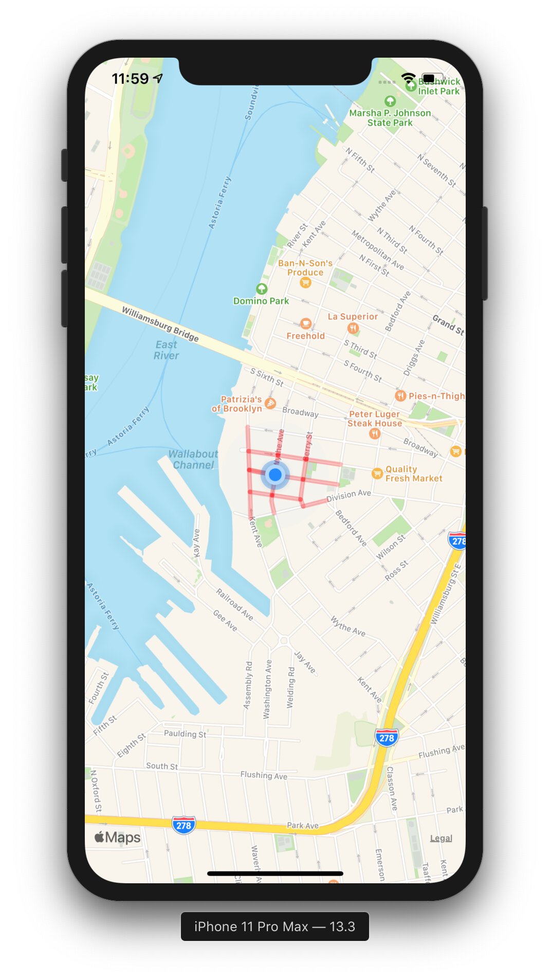
To start, I need to think about how I want this app to work. Ideally, I want to break streets up into segments by block. I’m defining a block here as the chunk of a street between any two adjacent intersections. For example, Division Avenue between Berry Street and Bedford Avenue is a block, as is Berry Street between Division Avenue and S 11th Street. To do this, I’ll need a way to represent a road segment so that I can store metadata about it. I’ll also need to know every possible road segment in New York so that I know what I have and have not visited. Getting at this data turns out to be not so straightforward.
# Apple Maps
I started by looking at what Apple would give me. When you want to render a map, Apple provides you with a view. They also provide you with a way to search for locations and a way to get directions between two locations.
However, there’s no way to get at any of the data directly. If I want the names of roads nearby, or even the name of the road that’s closest to my location, I’m out of luck. I needed to be able to get a catalog of road segments and identify the closest one from wherever I am. This data takes a while to collect, and anyone who’s collected enough of it isn’t willing to give it away, with the except the beautiful people who maintain OpenStreetMap.
# OpenStreetMap
OpenStreetMap is like Wikipedia for street data. It seemed like a natural place to look since its data is free to use and is constantly being updated. The reality is that map data is really, really big, and getting at the data for just New York City is gross. OpenStreetMap lets you export regions of map data, but exporting an area bigger than that a square mile or so ends up being too big a request for them to process. My options were either to:
- Download a lot of smaller regions and stitch them together.
- Download all of OpenStreetMap’s data in one big ol’ file and extract the data I needed.
Seeing as I didn’t know much about how to use this data, neither option seemed especially great. On the bright side, there are a few third parties that will extract data from OpenStreetMap for popular regions like cities. I ended up finding and downloading some of the data for New York City, which ended up being extremely detailed. The data included road segments, neighborhood names, building shapes, and everything else you might imagine needs to be represented on a map. It was also about a gig and a half of JSON, and while this level of detail is great, I only really needed data on roads.
# New York’s Centerline Data
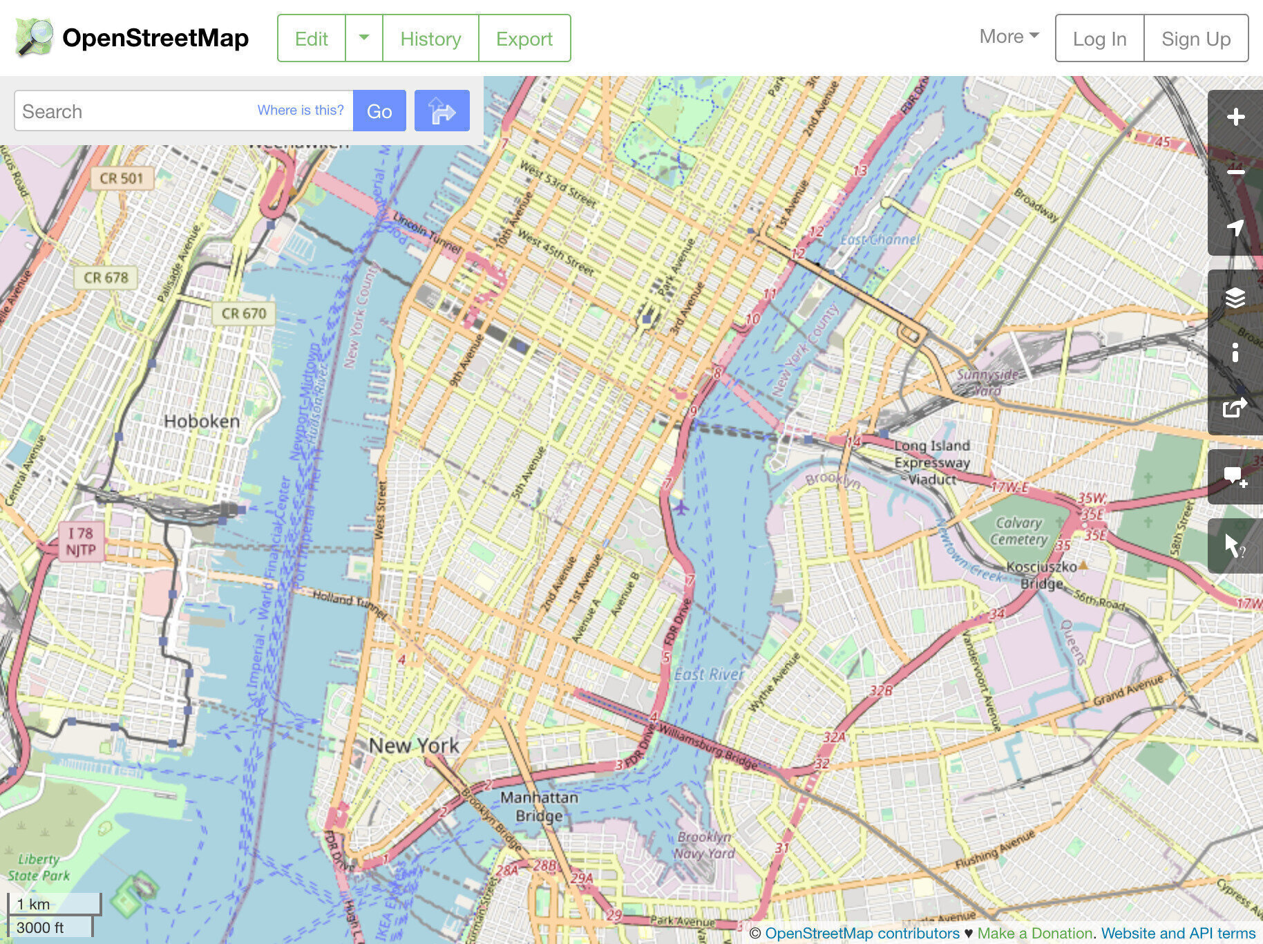
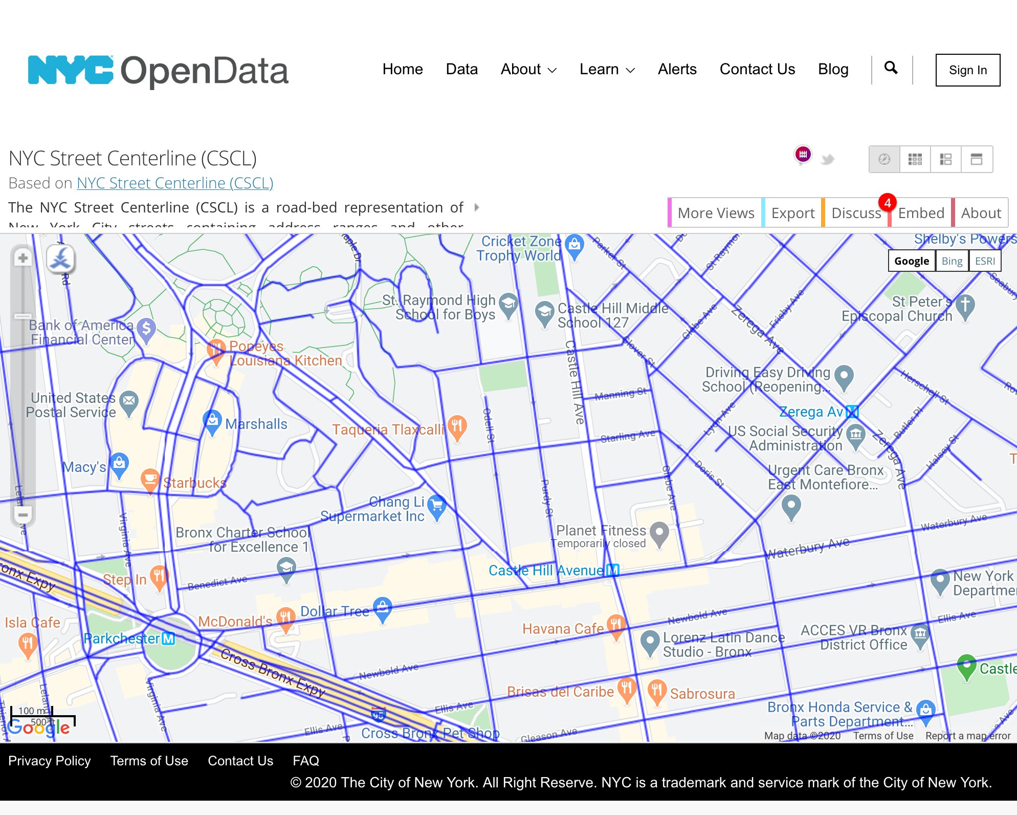
Around this time, I learned about New York City’s Open Data initiative. They host a project called The NYC Street Centerline, which holds data about New York’s roadbeds. It’s a fantastic start, but it’s not as polished as OpenStreetMap’s data. For example, take a look at this screenshot of NYC’s data on top of Google Maps. The blue lines are roads rendered from Centerline data. Note the discrepancies, especially around driveways, walking paths, and parking lots.
It also appears to be missing a lot of data about roads through some parks and cemeteries, which would be nice to know about. Here’s what Woodlawn Cemetery looks like, for example:
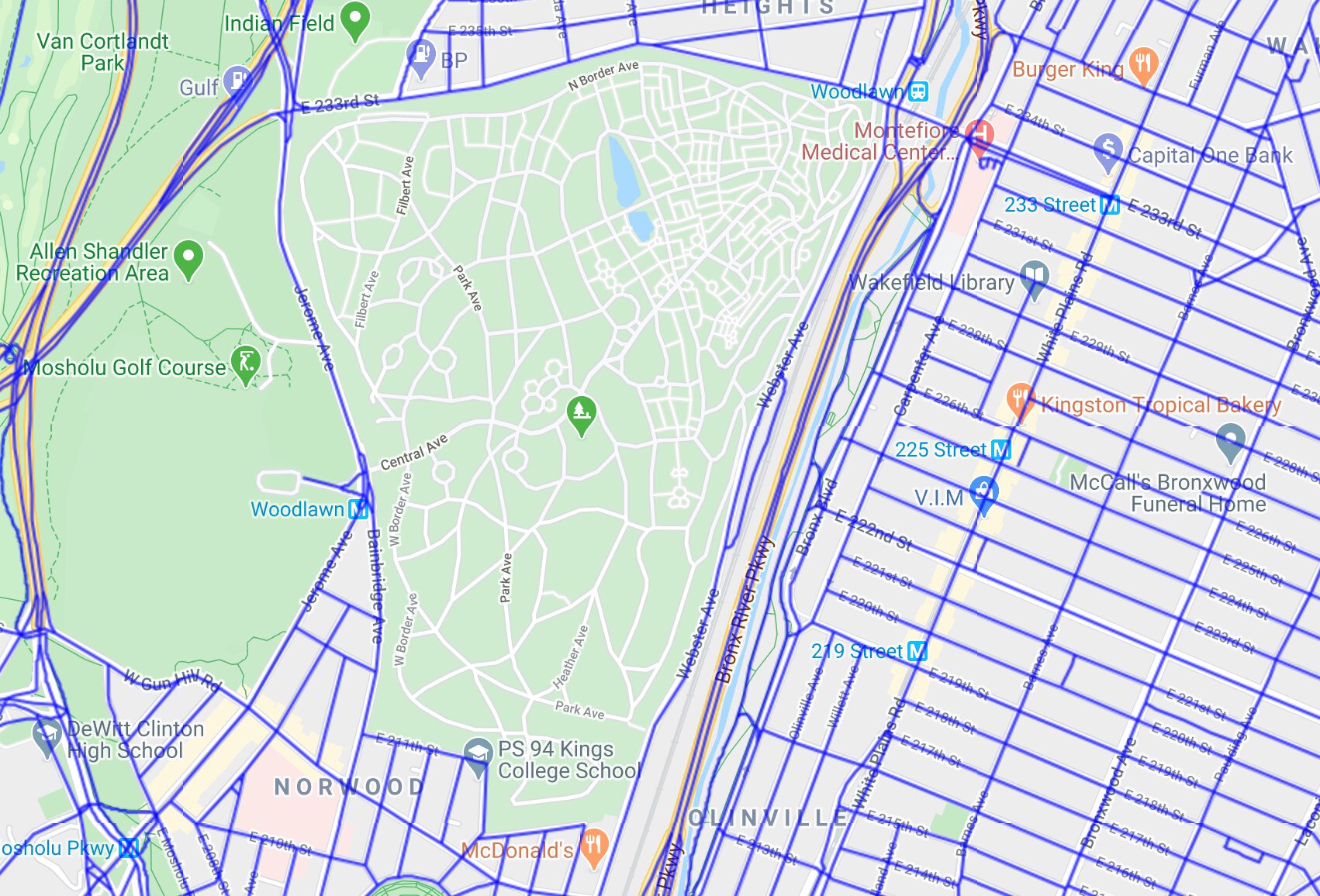
I’m betting OpenStreetMap’s data is more accurate than NYC’s here, but NYC’s data is a solid start. It’s exclusively road data, so the actual file size is about ten times smaller than the OpenStreetMap data for New York. Plus, it comes with a bunch of fun attributes, like how wide the road is, the street numbers on each side, and even what priority the street gets when snow needs to be plowed. I’m betting I’ll want to end up using OpenStreetMap at some point, but for now this seems like a good way to get started.
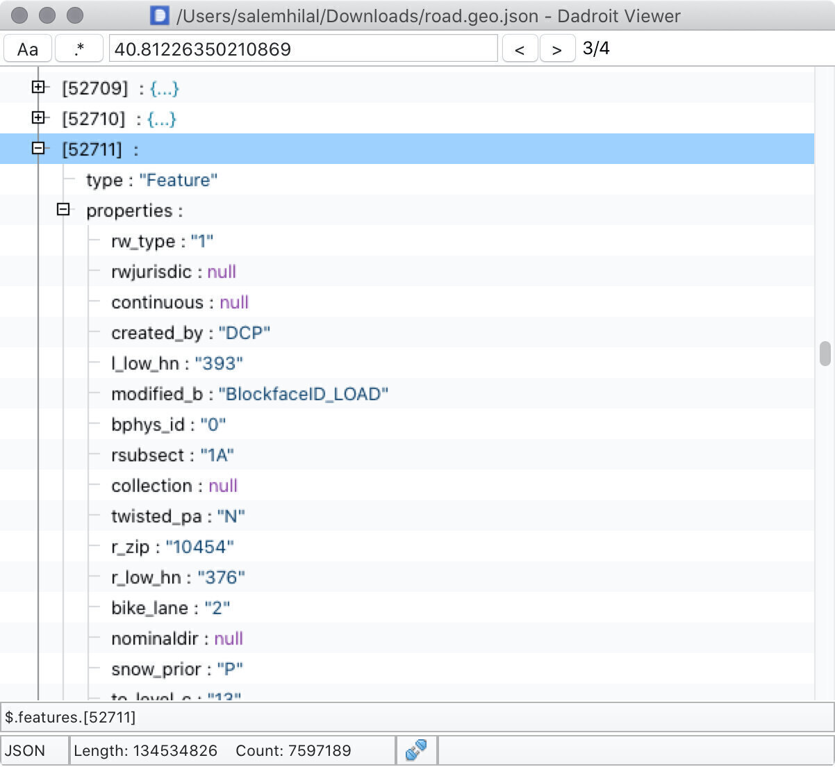
# Making sense of a 134.5MB JSON file
Centerline hosts their data in a bunch of different types of formats, but most of them looked like they’d require extra parsing to make sense of, as though they were all just created from dumps of a geospatial database. For example, JSON-formatted data was a list of un-keyed data, with the road’s coordinates encoded as a Multilinestring that would need to be parsed:
[
    "row-ahmi-vsc6~mfe8",
    "00000000-0000-0000-058D-BBD264543C90",
    0,
    1597147596,
    null,
    1597147596,
    null,
    "{ }",
    "341",
    "391",
    "62180",
    "MULTILINESTRING ((-73.9210350736335 40.81165142603656, -73.92058708344143 40.81226350210869))",
    "354",
    "374",
    "10454",
    "10454",
    "1422604712",
    "1422603138",
    "WILLIS AV",
    "2",
    "1",
    "2",
    "64",
    1196294400,
    1586822400,
    "TW",
    "1",
    "13",
    "13",
    "C",
    null,
    null,
    null,
    "AVE",
    null,
    null,
    "WILLIS AVE",
    "WILLIS",
    "TW",
    "255.162909019"
]
However, they did offer their data hosted as geoJson, which is a specification for encoding geodata as json (surprise). It’s a bit more verbose, so the filesize is a bit bigger, but filesize is a bit less of a concern when your data is already a hundred megabytes. In geoJson, that same road segment above instead looks like this (sorry in advance for all the scrolling you are about to do):
{
    "type": "Feature",
    "properties": {
        "rw_type": "1",
        "rwjurisdic": null,
        "continuous": null,
        "created_by": "DCP",
        "l_low_hn": "393",
        "modified_b": "BlockfaceID_LOAD",
        "bphys_id": "0",
        "rsubsect": "1A",
        "collection": null,
        "twisted_pa": "N",
        "r_zip": "10454",
        "r_low_hn": "376",
        "bike_lane": "2",
        "nominaldir": null,
        "snow_prior": "P",
        "to_level_c": "13",
        "joinid": null,
        "r_blockfac": "1422605356",
        "seglocstat": null,
        "nonped": null,
        "b5_sc": "278150",
        "created_da": "2007-11-29T00:00:00.000Z",
        "fire_lane": null,
        "within_bnd": null,
        "shape_leng": "263.63804189756",
        "special_di": null,
        "streetwidt": "64",
        "streetwi_1": null,
        "b7_sc": "27815001",
        "segmentlen": "263.63813458",
        "stname_lab": "WILLIS AV",
        "modified_d": "2015-12-22T00:00:00.000Z",
        "status": "2",
        "r_high_hn": "410",
        "l_zip": "10454",
        "avgtravtim": "0",
        "lsubsect": "1A",
        "sandist_in": null,
        "fcc": null,
        "from_level": "13",
        "boroughcod": "2",
        "posted_spe": "0",
        "trafdir": "TW",
        "l_blockfac": "1422604337",
        "physicalid": "62181",
        "borough_in": null,
        "accessible": null,
        "truck_rout": null,
        "l_high_hn": "409"
    },
    "geometry": {
        "type": "LineString",
        "coordinates": [
            [-73.92058708344143, 40.81226350210869],
            [-73.92011935314727, 40.81289384215231]
        ]
    }
}
I had a lot of trouble figuring out how to open and explore this file. Getting an understanding of its shape is a requirement if I wanted to parse it into any sort of app, and to do that I needed to poke around. Opening the file in Xcode caused it to crash pretty reliably. VSCode similarly hung for a while, and when it finally responded a bunch of navigation features seemed to be disabled. To help explore all of this data, I ended up using an app called Dadroit, a JSON viewer specifically made for viewing large files quickly.
Using Dadroit gave me enough context on the shape of the data to be able to munch through it in a simple Swift app. The parsing itself took a while, but I got far enough into the data to be able to highlight a bunch of random roads from it.
# What did we learn, Salem?
- There’s a lot of ways to represent geospatial data.
- Some of those ways are better than others.
- I’ll probably have to use OpenStreetMap data at some point, but it’s ok to take the easy way first.
- Map data is both complex and precious.
I want to write about how I sped up parsing this data, and then how I queried it for road segments close to where I am without using anything too fancy (like a geospatially-aware database). At the same time, this post is kinda long and I should go feed the dog or something. If you made it this far, thank you and let me know if I did anything too surprising in the comments box below.